Lake monitoring has a dirty secret: most of it still happens blind. Researchers lower a probe on a rope, take a sample from one spot, and call it a day. That approach misses the real picture. Algae blooms concentrate in patches. Sediment moves along specific channels. Thermal layers shift across a single afternoon. A point sample tells you about one cubic meter out of millions.
Underwater drones changed that. A small ROV can cover a hundred meters of shoreline in fifteen minutes, capture video at every depth, and log sensor readings continuously. The data is richer, the coverage is broader, and the cost is far below hiring a dive team. This article walks through the five drones that actually earn their keep in freshwater research, what their data means for lake health, and where each one falls short.
FIFISH
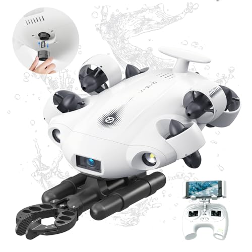
【2025 New】FIFISH V-EVO 4K60FPS Underwater Drone with Robotic Arm, with Removable SD Card, QYSEA AI Vision Lock 360° Omnidirectional Movement Underwater ROV with Depth Hold,330ft Dive
- 4K 60FPS High Frame-rate Camera: Create epic footage and wonderful underwater moments with V-EVO's upgraded camera system, achievi…
- Removal SD Card: The new version is a removable SD card, providing you with more convenient gameplay and storage functions. The FI…
- 360° Omnidirectional Mobility: Reach beyond the limits of traditional methods, and achieve full 360° freedom in underwater mobilit…
Why Lake Monitoring Demands Specialized Underwater Drones
Lakes are not miniature oceans. They have warmer surface layers, colder deep water, and a sharp boundary between them called the thermocline. That boundary shifts daily with weather. It also traps debris, suspended sediment, and dissolved gases in distinct bands. A drone built for open-ocean inspection will struggle with these conditions. Freshwater environments need vehicles that handle low visibility, tangled vegetation, and soft sediment bottoms without stirring everything up.
The tether matters more than most buyers realize. In a lake, you are rarely far from shore, but you are often working around docks, boat ramps, and submerged logs. A 100-meter tether feels generous until you try to cross a cove. The top drones for lake work carry at least 150 meters of cable, and the best ones push past 300 meters. Battery life is the other constraint. A drone that runs 45 minutes at full thrust will last closer to 25 minutes when fighting a mild current. Plan your transects accordingly.
One more difference: freshwater equipment faces biofouling. Zebra mussels, algae, and bacterial slime attach to hulls and thrusters within weeks. Ocean drones get cleaned after every deployment. Lake drones need the same discipline, plus regular inspection of the tether where it rubs against rocks and concrete.
Top 5 Underwater Drones for Lake Monitoring in 2026
1. FIFISH V-EVO — Best for Advanced Data Collection
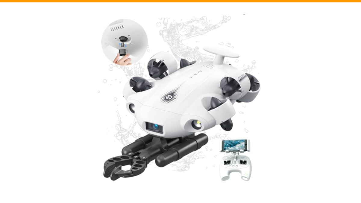
The FIFISH V-EVO stands out because it combines a professional camera with a tool that does real work underwater. The 4K 60FPS camera captures sharp footage of sediment layers, aquatic vegetation, and fish behavior. The 166-degree ultra-wide lens is not a gimmick — it lets you see the full context of a monitoring site without panning across multiple passes. The 5000-lumen LED array handles murky freshwater conditions that leave lesser lights producing brown-out footage.
What makes it genuinely useful for monitoring is the 360-degree omnidirectional movement. Traditional ROVs move forward, backward, and turn. The V-EVO holds a fixed position while rotating in place, which matters when you are trying to inspect a pipe intake or photograph the same patch of lakebed from multiple angles. The depth rating of 330 feet covers the vast majority of inland lakes, including the deepest natural ones in the United States.
The robotic arm is the feature that separates it from camera-only drones. You can retrieve a sediment sample, snag a piece of invasive plant matter for lab analysis, or clear debris away from a sensor you are trying to read. The removable SD card is a practical upgrade — you can swap cards in the field instead of downloading over a slow connection. For a research team that needs video, stills, and physical samples from one deployment, this is the most complete package.
It is not cheap, and the learning curve for the omnidirectional controls takes a few hours. But for serious monitoring work, the versatility pays for itself quickly.
2. Chasing M2 Pro — Best for Professional Water Quality Surveys
The Chasing M2 Pro is the workhorse of scientific lake surveys. It carries a 4K UHD camera with a 1-inch sensor, which produces cleaner low-light footage than the smaller sensors in consumer drones. That matters when you are shooting below the thermocline where natural light barely penetrates. The 162-degree field of view captures wide transects, reducing the number of passes needed to cover a study area.
Its real strength is modularity. The M2 Pro accepts interchangeable payloads, including a water sampler and a sonar module. You can run a transect, collect water at specific depths, and switch to sonar scanning on the next dive. The 400-meter tether is the longest in this class, which gives you the range to cross large basins without moving the shore station. The 6-hour battery life on the controller outlasts any field day you will plan.
The trade-off is weight. At over 5 kilograms, it is not a casual throw-in-the-backpack drone. You need a proper case and a stable surface for launch. But for a research team running weekly surveys, the M2 Pro is the one that will still be working after two seasons of hard use.
3. Gladius Mini S — Best Budget Option for Small Lakes
The Gladius Mini S is the drone you buy when the budget committee says no. It delivers 4K video and a 100-meter tether at roughly half the price of the professional units. The 46-minute battery life is respectable, and the 150-meter depth rating covers most small to medium lakes. The camera produces good color in clear water, though it struggles in turbid conditions above 10 NTU.
For basic tasks — confirming aquatic vegetation distribution, checking dock pilings, or photographing sediment buildup near a culvert — it gets the job done. The lack of interchangeable sensors means you are limited to visual inspection and whatever external probe you can rig to the frame. That is fine for preliminary assessments. It is not sufficient for peer-reviewed research.
One honest caveat: the Mini S feels light in currents. In a lake with any wind-driven surface flow, it drifts more than the heavier units. Keep your transects short and your expectations realistic.
4. Deep Trekker DTG3 — Best for Deep-Lake Sediment Mapping
The Deep Trekker DTG3 is a different animal. It is a rugged, spherical ROV built for industrial inspection, and it happens to be excellent at lakebed work. The 365-meter depth rating handles the deepest freshwater lakes on Earth. The 150-meter tether is standard, but you can extend it to 300 meters for large basins. The 4K camera is mounted on a rotating head, so you can look straight down at sediment layers without tilting the whole vehicle.
Its key advantage for sediment mapping is stability. The spherical hull resists current-induced roll, and the thrusters are positioned to hold a precise depth while the camera does a slow vertical pan. That stability produces the kind of consistent footage that photogrammetry software can stitch into accurate 3D models of the lakebed.
The downsides are real. It is the most expensive unit in this list, and the battery is integrated rather than swappable, which means a full recharge takes over two hours. The controls take practice — the joystick layout is designed for industrial operators, not casual users. But for deep-lake work where accuracy matters more than convenience, the DTG3 is the reference standard.
5. Chasing Dory — Best for Quick, Entry-Level Assessments
The Chasing Dory is the smallest drone here, and that is its superpower. It weighs just over 1 kilogram, fits in a backpack, and deploys in under two minutes. The 1080p camera is adequate for reconnaissance, and the 15-meter tether is enough for shallow water near docks, beaches, and boat ramps. The 60-meter depth rating covers the littoral zone where most invasive species and algae problems start.
Use it for what it is: a visual inspection tool. You can confirm whether that dark patch is a weed bed or a shadow, check if the swim platform is accumulating sediment, or document shoreline erosion after a storm. The footage is not publication-grade, but it is more than enough for a preliminary site assessment before you deploy the heavy equipment.
The short tether is the limiting factor. Fifteen meters disappears quickly when you are working from a floating dock. Plan your launch points carefully, and keep the Dory within line of sight at all times.
How to Read Sonar and Imaging Data for Lake Health
Capturing footage is the easy part. Interpreting it is where most monitoring projects go sideways. Here is what to look for in your data.
Sonar returns from a lakebed tell you about sediment type. A hard, bright return with a sharp bottom edge means sand or gravel. A soft, diffuse return with a fuzzy bottom edge means silt or organic muck. If you see the sonar return fade out gradually, you are looking at a layer of soft sediment that may be decades old. That layer is where nutrients like phosphorus bind to particles — and where they get released when oxygen levels drop.
Imaging data reveals vegetation patterns. A healthy lake has a mix of submerged, floating, and emergent plants distributed in depth zones. If you see a single species dominating a wide band, that is a red flag. Eurasian watermilfoil and curly-leaf pondweed both form monocultures that crowd out native plants. The drone footage lets you map the edges of these patches and track their spread season over season.
Water clarity readings from the camera feed are useful, but they need calibration. The human eye is terrible at judging turbidity. Use a Secchi disk reading at the surface, then compare that to the drone footage at depth. The difference tells you whether the turbidity is uniform or concentrated in a specific layer — which usually points to a sediment inflow source.
Key Specs to Compare: Tether Length, Depth, and Battery Life
Three numbers dominate every buying decision, and they interact in ways that are not obvious at first glance.
| Drone | Tether Length | Depth Rating | Battery Life | Best For |
|---|---|---|---|---|
| FIFISH V-EVO | 150 m | 100 m | ~45 min | Data collection with robotic arm |
| Chasing M2 Pro | 400 m | 150 m | ~60 min | Professional surveys, modular payloads |
| Gladius Mini S | 100 m | 150 m | ~46 min | Budget visual inspections |
| Deep Trekker DTG3 | 150 m (extendable to 300 m) | 365 m | ~50 min | Deep-lake sediment mapping |
| Chasing Dory | 15 m | 60 m | ~60 min | Shallow-water reconnaissance |
Tether length is not a measure of how far you can go. It is a measure of how far you can go and still get the signal back. Voltage drops over long cables, so a 400-meter tether may only give you reliable 4K video out to 350 meters. The M2 Pro compensates with thicker cabling and signal boosters, but it is still a physical limit.
Depth rating is rarely the bottleneck in lakes. Most inland lakes are under 50 meters deep. The exception is the deep glacial lakes — Tahoe, Superior, Pend Oreille — where the DTG3’s 365-meter rating becomes essential. For everyone else, a 100-meter rating leaves plenty of margin.
Battery life is the number that actually limits your field day. A 45-minute battery means you can run maybe 10 transects of 4 minutes each before you need to recharge. That is enough for a morning of work, but not a full day. Buy a second battery if the drone supports it. The V-EVO and M2 Pro both allow hot-swapping, which extends your usable time significantly.
Integrating Drone Data with GIS and Water-Quality Software
The footage is only valuable if it ends up in your analysis pipeline. Here is the workflow that works for research teams.
Export your video and stills with GPS tags enabled. The V-EVO and M2 Pro both embed location data in the file metadata. Import those files into QGIS or ArcGIS as a raster layer. Georeferenced video frames can be stitched into a mosaic that shows the entire lakebed in one image. This becomes your baseline map for future comparisons.
For water quality data, export the readings from your external probe and join them to the drone’s depth and position log. Most teams use a simple CSV export, then merge in R or Python. The key is to timestamp everything consistently. If your drone logs at 10 Hz and your probe logs at 1 Hz, you need to interpolate the probe data to match the drone’s timeline.
Sonar data from modules like the M2 Pro’s payload can be exported in XTF or S7K formats, which are standard in hydrographic software. From there, you can generate bathymetric maps, sediment classification layers, and volume calculations for sediment buildup. These outputs are what justify the drone purchase to a grant committee — they are not just cool footage, they are quantitative data.
Common Lake Conditions That Challenge Drones (and How to Overcome Them)
Freshwater is not forgiving. Here are the conditions that will test your equipment, and what to do about them.
Thermoclines. The boundary between warm surface water and cold deep water is a density gradient that can refract sonar signals and scatter light. You will see a shimmering distortion in the video feed. The workaround is to approach the thermocline at a shallow angle rather than diving straight through it. That reduces the refraction effect and gives you a clearer image of what lies below.
Aquatic vegetation. Dense weed beds can snag propellers and wrap around tether cables. The V-EVO’s 360-degree thrusters help you back out of a tangle, but prevention is better. Run your transects parallel to weed beds, not through them. If you must cross, slow down and keep the thrusters at minimum speed.
Low visibility. Turbidity above 20 NTU turns the best camera into a brown blur. The 5000-lumen lights on the V-EVO help, but they also reflect off suspended particles, creating a snowstorm effect. Reduce your light intensity and move closer to the target. Sometimes the best footage comes from a slow, close pass rather than a wide shot.
Soft sediment. Landing on a silty bottom is a mistake. The thrusters will stir up a cloud that ruins visibility for minutes. Keep the drone hovering at least 30 centimeters above the lakebed, and use the robotic arm to gently touch the surface if you need a sample.
Cost Analysis: Is a Drone Cheaper Than Traditional Sampling?
The short answer is yes, but only if you run enough surveys. A single day of boat-based sampling with a two-person dive team costs $800 to $1,500 depending on your region. Add lab analysis and you are looking at $2,000 per sampling event. A drone like the FIFISH V-EVO costs several times that upfront, but it replaces the dive team for visual inspections and sediment photography.
Run the numbers over a single season. If you do monthly surveys for six months, that is $12,000 in traditional sampling costs. The drone pays for itself in the first half of the season, and it produces more data per deployment. The maintenance costs are real — thrusters need cleaning, propellers need replacing, and the tether will eventually need repair. Budget 10-15% of the purchase price per year for parts and service.
The hidden cost is training. Expect to spend a full day learning the controls and another day practicing in the lake before you collect usable data. That is a small price compared to the alternative of hiring a specialist every time you need a survey.
Frequently Asked Questions About Lake Monitoring Drones
Can I use a fishing drone for scientific lake monitoring?
Fishing drones are built to locate fish, not to collect environmental data. They lack the sensor ports and the stability needed for systematic transects. You can attach a temperature probe to some models, but the data quality will be inconsistent. Buy a purpose-built ROV if you need defensible data.
How deep do I need the drone to go for most lake work?
Ninety percent of lake monitoring happens above 30 meters. The thermocline in most temperate lakes sits between 5 and 15 meters. The deepest point of a typical reservoir is under 40 meters. A 100-meter depth rating covers virtually all inland scenarios. The 365-meter rating of the DTG3 is only necessary for the deepest glacial lakes.
What is the best way to keep the tether from getting tangled?
Use a tether management system — a reel that pays out line as the drone moves. Do not let the tether float freely on the surface. Keep it taut by having an operator feed it out manually while watching the drone’s position. The V-EVO and M2 Pro both have management reels that make this easier.
Can these drones operate in winter under ice?
Yes, with the right setup. You need to cut a hole in the ice large enough for the drone and manage the tether from above. The cold reduces battery life by up to 30%, so plan shorter dives. The drone itself is fine in freezing water — the electronics generate enough heat to keep the seals working.
Do I need a special permit to fly a drone in a lake?
Underwater drones are not subject to FAA regulations because they do not operate in airspace. However, you may need a permit from the local water authority or park service, especially in protected areas. Check with the lake manager before deploying. It is also good practice to inform nearby boaters, since the tether can be a hazard.
Bottom Line: Choosing the Right Drone for Your Lake Project
- Match the drone to the task. Visual inspection needs a good camera; sediment mapping needs sonar; sample retrieval needs a robotic arm. No single drone does all three perfectly.
- Prioritize tether length over depth rating. You will hit the tether limit far more often than the depth limit in most lakes.
- Budget for a second battery and a spare propeller set. These are the two items that will fail or run out when you need them most.
- Learn the data workflow before you buy. If you cannot export GPS-tagged video and merge it with sensor logs, the drone is just an expensive toy.
- Check the current price on Amazon for any drone on this list — prices fluctuate with supply and new model releases.
- Start with a small, shallow-water survey to learn the controls. The Chasing Dory is perfect for this. Move to the heavier equipment once you understand the basics.
- Document everything. The footage you capture this season is the baseline you will compare against next season. Store it in a structured folder with consistent naming conventions.
The right underwater drone turns a lake from a mystery into a map. It gives you the ability to see what is happening below the surface, measure it, and track it over time. Whether you are tracking an algae bloom, mapping sediment, or documenting invasive species, the tools above will get you there. The investment is real, but so is the payoff in data quality and coverage.
