You’re twelve miles offshore and the fog rolls in like a curtain. Your phone’s battery is at fourteen percent, and the only thing your old GPS unit can tell you is that it’s lost. That’s the moment you wish you’d upgraded your marine electronics sooner.
Garmin builds a wide range of chartplotters, from handheld units that float to large touchscreen systems with built-in sonar. The right one depends on your boat, your budget, and how you fish or cruise. Some units focus on navigation, others bundle fishfinding into the same box. A few handle both jobs brilliantly.
This roundup covers five very different Garmin units. You’ll see the OnBoard MOB safety system, two rugged handhelds, a compact touchscreen chartplotter, and a car navigator that’s handy for trailering. We’ll also cover transducer compatibility, sunlight readability, integration with radar and autopilot, and the hidden costs that don’t show up on the spec sheet.
Compare the key specs across these five units before diving into the details.
| Features | OnBoard MOB System | GPSMAP 79sc | ECHOMAP UHD2 64sv | Drive 53 | GPSMAP 79s |
|---|---|---|---|---|---|
| Primary Function | Man overboard safety | Handheld marine GPS | Touchscreen chartplotter | Road navigator | Handheld marine GPS |
| Display Size | No display | High-res color | 6-inch touchscreen | 5-inch touchscreen | High-res color |
| Preloaded Maps | None | BlueChart g3 coastal | Navionics+ coastal | City & highway | Worldwide basemap |
| Key Feature | Engine cutoff on captain MOB | Floats, 10,000 waypoints | GT54 transducer, SideVü | Tripadvisor ratings | Floats, 10,000 waypoints |
| Best Use Case | Safety add-on for MFDs | Offshore navigation | Fishing & coastal cruising | Towing & road trips | Budget handheld nav |

Garmin OnBoard MOB System
Garmin
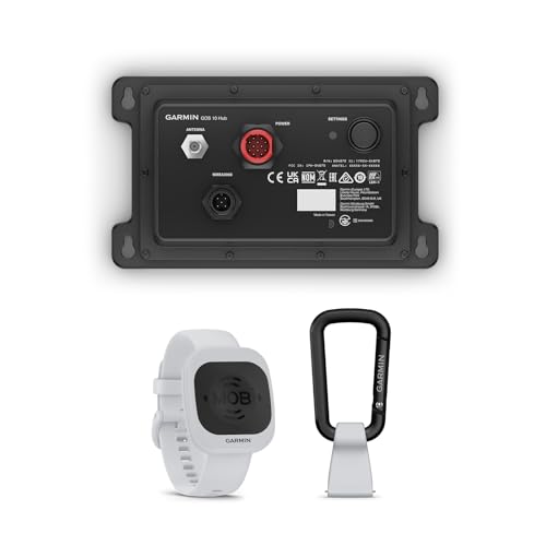
Garmin OnBoard™ System, Mob System, Uses Wireless Tags
- Wireless wearable MOB tags can be worn on a wrist band, carabiner or key ring float
- MOB tags can be designated as either captain or passenger — changing their MOB actions
- Passenger MOB tag detection will trigger MOB on MFDs — plus an audible alarm on MFDs and hub
The Garmin OnBoard system is a wireless man-overboard safety net. It uses small wearable tags that you attach to a wrist band, carabiner, or key ring float. If someone falls in, the system knows almost instantly.
What makes this different from a simple alarm is how it responds. Each tag is assigned a role. A passenger tag triggers a MOB alert on your compatible chartplotter displays plus an audible alarm on the MFDs and the hub. A captain tag does all that and also cuts the engine. That’s a huge deal if you’re running the boat alone or with a small crew.
The integration with Garmin chartplotters is where this shines. You can temporarily disable tags when you’re swimming or rafting up, so you don’t get false alarms. The system is designed for boats with Garmin MFDs, so it won’t work as a standalone device. That’s the main limitation to understand before buying.
- Wireless tags work on wrist bands, carabiners, or key ring floats
- Captain tags trigger engine cutoff plus chartplotter MOB alert
- Passenger tags trigger MOB alert and audible alarm on MFDs and hub
- Can temporarily disable tags for hassle-free swimming stops
- Requires compatible Garmin chartplotter and hub for full operation
Best for: Boat owners with existing Garmin MFDs who want a serious layer of crew safety without wiring individual kill switches.
Garmin GPSMAP 79sc Handheld

Garmin
Garmin GPSMAP 79sc, Marine GPS Handheld Preloaded with BlueChart g3 Coastal Charts, Rugged Design and Floats in Water
- Rugged, floating, water-resistant (IPX6 — unit level only) handheld GPS with a high-resolution color display and scratch-resistant…
- Increased memory to save and track 10,000 waypoints, 250 routes and 300 fit activities
- Supports multiple satellite constellations (GPS, GLONASS, Beidou, Galileo, QZSS and SBAS) for reliable tracking around the world
The GPSMAP 79sc is a rugged handheld GPS built for boaters who need navigation without a fixed dash install. It floats, so you don’t have to worry about dropping it overboard. The IPX6 water resistance handles rain and spray, though you shouldn’t submerge it.
The preloaded BlueChart g3 coastal charts are the big draw here. You get detailed depth contours, wrecks, and obstructions for U.S. coastal waters right out of the box. The high-resolution color display is readable in direct sunlight, and the scratch-resistant, fogproof glass holds up to salt spray and knocks.
Storage is generous. You can save 10,000 waypoints and 250 routes, which is plenty for a season of serious fishing or cruising. The built-in 3-axis tilt-compensated electronic compass shows your heading even when you’re standing still, which is handy when you’re drifting and need a reference.
The trade-off is the screen size. It’s a handheld, so the display is small compared to a fixed chartplotter. You won’t want to navigate a tricky inlet with this as your primary unit, but as a backup or for a skiff, it’s excellent.
- Floats in water and rated IPX6 for splash resistance
- Preloaded BlueChart g3 coastal charts for U.S. waters
- 10,000 waypoints, 250 routes, and 300 fit activities
- Multi-constellation support: GPS, GLONASS, Beidou, Galileo, QZSS, SBAS
- 3-axis tilt-compensated electronic compass works while stationary
Best for: Kayak anglers, dinghy sailors, or anyone who wants a reliable backup GPS that can take a beating and float if dropped.
Garmin ECHOMAP UHD2 64sv

Garmin
Garmin ECHOMAP UHD2 64sv with GT54 Transducer, 6” Touchscreen Chartplotter, Garmin Navionics+ U.S. Coastal
- Easy-to-use 6” chartplotter with a bright, sunlight-readable touchscreen display
- Included GT54-TM transducer for Garmin traditional, ClearVü and SideVü scanning sonars
- Built-in Garmin Navionics+ coastal charts with integrated Navionics data
The ECHOMAP UHD2 64sv is a 6-inch touchscreen chartplotter that packs a serious punch for its size. It comes with the GT54 transducer, which gives you Garmin traditional sonar, ClearVü, and SideVü scanning. That’s a complete fishfinding package in one box.
The built-in Garmin Navionics+ coastal charts are a major plus. You get detailed coastal mapping with integrated Navionics data, so you can see depth, wrecks, and bottom composition without buying a separate card. The touchscreen is bright and sunlight-readable, which is critical when you’re at the helm on a sunny day.
Wireless connectivity sets this unit apart. You can share sonar, waypoints, and routes with another ECHOMAP UHD2 chartplotter over Wi-Fi. It also connects wirelessly to a Garmin Force trolling motor, letting you create and follow routes, navigate to waypoints, control speed, and check battery life from the screen.
The 6-inch screen is compact, so split-screen views get cramped. If you want to see sonar and chart side by side, you might find yourself squinting. But for a center console or a smaller boat, the size keeps the dash clean.
- 6-inch touchscreen with sunlight-readable display
- GT54-TM transducer supports traditional, ClearVü, and SideVü sonar
- Built-in Navionics+ coastal charts with integrated data
- Wi-Fi sharing of sonar, waypoints, and routes between units
- Wireless control of Force trolling motors with route following
Best for: Anglers who want a complete sonar plus chartplotter combo on a mid-size boat without spending a fortune.
Garmin Drive 53 GPS Navigator

Garmin
Garmin Drive™ 53 GPS Navigator
- Bright, high-resolution 5” glass capacitive touchscreen display lets you easily view your route
- Get more situational awareness with alerts for school zones, speed changes, sharp curves and more
- View food, fuel and rest areas along your active route, and see upcoming cities and milestones
The Garmin Drive 53 is a 5-inch car GPS navigator, but it earns a spot here because it’s the perfect companion for trailering your boat. You mount it in your truck or SUV, and it gets you to the ramp without relying on your phone’s signal.
The 5-inch glass capacitive touchscreen is bright and responsive. It shows your route clearly, and the alerts for school zones, speed changes, and sharp curves keep you aware on unfamiliar roads. That’s genuinely useful when you’re towing a 24-foot boat and need advance warning of a tight curve.
You also get Tripadvisor ratings for restaurants, hotels, and attractions along your route. That’s handy for planning a lunch stop on a long tow. The directory of U.S. national parks simplifies navigation to entrances, visitor centers, and landmarks, which is nice if you launch near a park.
The obvious limitation is that it’s not a marine unit. It won’t float, and it doesn’t have any nautical charts. But if you’re looking for a reliable way to get your boat to the water, this does that job well.
- 5-inch glass capacitive touchscreen with high resolution
- Alerts for school zones, speed changes, and sharp curves
- Food, fuel, and rest areas shown along active route
- Tripadvisor ratings for restaurants, hotels, and attractions
- U.S. national parks directory with entrances and landmarks
Best for: Boat owners who tow regularly and want a dedicated GPS that won’t drain their phone battery or lose signal in rural areas.
Garmin GPSMAP 79s Handheld

Garmin
Garmin GPSMAP 79s, Marine GPS Handheld with Worldwide Basemap, Rugged Design and Floats in Water
- Rugged, floating, water-resistant (IPX6 — unit level only) handheld GPS with a high-resolution color display and scratch-resistant…
- Increased memory to save and track 10,000 waypoints, 250 routes and 300 fit activities
- Supports multiple satellite constellations (GPS, GLONASS, Beidou, Galileo, QZSS and SBAS) for reliable tracking around the world
The GPSMAP 79s is the sibling to the 79sc, but it comes with a worldwide basemap instead of coastal charts. That makes it a more versatile travel companion if you boat in different regions or take trips abroad.
It shares the same rugged, floating design and the same high-resolution color display. The memory capacity is identical: 10,000 waypoints, 250 routes, and 300 fit activities. You also get the multi-constellation satellite support and the 3-axis tilt-compensated electronic compass.
The key difference is the mapping. The worldwide basemap shows major roads, cities, and coastlines, but it lacks the detailed depth contours and obstructions of the BlueChart g3 charts on the 79sc. If you navigate coastal waters, you’ll want to buy additional charts or go with the 79sc.
For inland lakes and rivers, the basemap is often sufficient. You’ll see the shoreline and your position, which is enough for many recreational boaters. But serious anglers will miss the detailed bottom structure.
- Rugged, floating, IPX6 water-resistant design
- Worldwide basemap with major roads and coastlines
- 10,000 waypoints, 250 routes, and 300 fit activities
- Multi-constellation support for reliable tracking anywhere
- 3-axis tilt-compensated electronic compass
Best for: Cruisers and travelers who need a durable handheld GPS for global navigation without the cost of regional chart cards.
How We Chose These Products
We focused on real-world utility, not just spec sheets. Each unit was evaluated for its intended use case, build quality, and how well it integrates with other marine electronics. We looked at what Garmin actually ships, from the transducer to the preloaded maps, and considered the total cost of ownership.
We also considered the buyer’s perspective. A handheld GPS serves a different need than a fixed chartplotter. The OnBoard system is a safety device, not a navigation tool. The Drive 53 is for the tow vehicle. By covering these distinct categories, you can find the right tool for your specific situation.
Buying Guide: What Really Matters
Before you buy, think about where you’ll mount the unit. An open helm with direct sun exposure demands a display with high brightness and good anti-glare. A closed helm gives you more flexibility, but you still want a screen you can read at a glance. The ECHOMAP UHD2 64sv and the handheld units both handle sunlight well.
Consider your transducer needs. If you fish, the GT54 transducer on the ECHOMAP gives you CHIRP, ClearVü, and SideVü. Older transducers may not be compatible with new units, so check what you have before upgrading. If you’re starting fresh, the included transducer is a solid choice.
Integration matters more than most people think. Does the unit support NMEA 2026 for autopilot and AIS? Can it share data with radar? The ECHOMAP series supports these connections, but the handhelds don’t. Map subscription costs also add up. Navionics+ updates and premium Garmin maps require ongoing fees, so factor that into your budget.
Our Top Recommendation
The Garmin ECHOMAP UHD2 64sv is the best all-around choice for most boaters. It combines a chartplotter, sonar, and wireless connectivity in one package. The 6-inch touchscreen is bright enough for open helms, and the built-in Navionics+ charts cover coastal waters out of the box. It’s not the cheapest option, but it delivers the most value for the money.
If you need a backup or a portable unit, the GPSMAP 79sc is excellent thanks to its BlueChart g3 coastal charts. For a budget-friendly handheld, the GPSMAP 79s covers the basics. And if safety is your top priority, the OnBoard system is a smart addition to any Garmin MFD setup.
Frequently Asked Questions
Can I use my old Garmin transducer with a new chartplotter?
Not always. Garmin uses different transducer connectors and protocols. The GT54 transducer that ships with the ECHOMAP UHD2 64sv is not compatible with older units that use a different port. Check the connector type on your old transducer and compare it to the new unit’s input. If they don’t match, you’ll need an adapter or a new transducer.
How much power does a chartplotter draw?
A 6-inch unit like the ECHOMAP UHD2 64sv typically draws around 1.5 to 2 amps at 12 volts with the backlight at full brightness and sonar running. That’s manageable for a standard starting battery, but it will drain a trolling motor battery quickly. Always wire the chartplotter to a dedicated fused circuit rated for the unit’s amp draw.
Do I need an external GPS antenna?
No, most Garmin chartplotters have a built-in GPS receiver. But if you mount the unit in a location with poor sky view, like under a hardtop or in a console, an external antenna can improve reception. The handheld units work fine without one because you hold them in the open.
What’s the difference between BlueChart g3 and Navionics+?
BlueChart g3 is Garmin’s own coastal chart format, preloaded on the GPSMAP 79sc. Navionics+ is a separate chart product that Garmin now bundles with the ECHOMAP UHD2 series. Both provide detailed coastal mapping, but Navionics+ includes some inland lake data and integrates with the Garmin Navionics app for updates. You cannot mix them on the same unit.